
Accessing land survey details is very important for landowners, farmers, and property buyers in Karnataka. To make land information transparent and easily available, the Government of Karnataka has introduced digital services such as Nimm Jamin, Bhoomi, and the Dishaank app
Using these platforms, citizens can view survey maps, land boundaries, survey numbers, and land extent details online, in many cases free of cost.
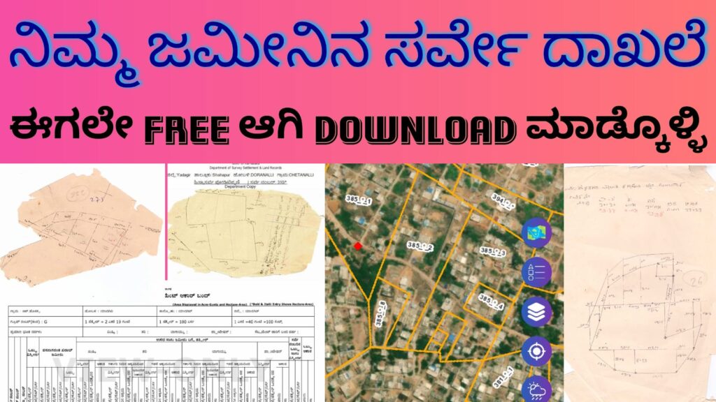
What Is Nimm Jamin?
Nimm Jamin means “My Land” and refers to Karnataka’s digital land information initiative that helps citizens access their land survey details online. It allows users to view official survey maps prepared by the Department of Survey, Settlement, and Land Records (DSSL&R).
These maps show the exact layout of land parcels and help users understand the physical location of their land.
What Information Is Available in Survey Maps?
Survey maps contain important land-related details such as:
- Survey Number and Sub-division (Hissa Number)
- Exact land boundaries and shape
- Total land extent
- Adjacent survey numbers
- Village layout and access paths
Older hand-drawn maps and updated digital maps may both be available, depending on the village and survey status.
How to Check Nimm Jamin Survey Details Online
Land survey details in Karnataka can be accessed through multiple official platforms:
1. Bhoomi Land Records Portal
- View RTC (Pahani) details
- Check land ownership information
- Confirm survey and hissa numbers
2. Dishaank Mobile App
- View survey boundaries on satellite maps
- Locate survey numbers using GPS
- Compare ground location with official land records
3. Digitized Survey Map Services (Nimm Jamin)
- View scanned village survey maps
- Access land sketch and boundary drawings
- Download survey maps for reference purposes
Most basic services are available free of cost, while certified copies may require a nominal government fee.
Benefits of Checking Survey Details Online
- Clear Land Boundaries
Helps avoid disputes with neighboring landowners. - Better Land Identification
Makes it easy to locate land using survey numbers. - Helpful for Property Transactions
Buyers can verify land shape and location before purchase. - Saves Time and Effort
No need to visit government offices for basic land information.
Important Things to Remember
- Online survey maps are mainly for reference purposes.
- For legal cases or registration, always use certified land records.
- Land measurement in Karnataka follows the Acre–Gunta system
(40 Guntas = 1 Acre). - Minor differences may exist between satellite maps and ground measurements.
Who Can Use Nimm Jamin Survey Services?
- Farmers and agricultural landowners
- Residential plot owners
- Real estate buyers and sellers
- Land developers and builders
- Legal professionals and surveyors
Why Nimm Jamin Is Important
In the past, landowners had to depend on manual records and repeated visits to survey offices. Nimm Jamin and related digital services have reduced paperwork, improved transparency, and helped citizens access land data from anywhere.
These services play a major role in preventing land disputes and ensuring clarity in land ownership.
Conclusion
The Nimm Jamin Survey Details system, along with Bhoomi and Dishaank, has made land record access in Karnataka simple and user-friendly. From checking survey maps to identifying boundaries, these tools empower citizens with accurate land information.
For any legal or financial land transaction, always verify details using official government portals and obtain certified copies when required.
Need More Content?
I can also:
- Add FAQs (common questions people search on Google)
- Write a step-by-step “How to Download Survey Map” guide
- Create SEO title, meta description, and keywords
- Rewrite this as a landing page or app description